The Extremely Severe Cyclone Fani is gradually coming closer to the coast and is all set to make landfall over Odisha coast. It is expected to cross Odisha coast near Satpada and Balukhand area in Puri district around the afternoon of May 3. Cyclone Fani is presently centred about 640 Km south-southwest of Puri, Odisha, and 395 km south-southeast of Vishakhapatnam, Andhra Pradesh. Thus, Odisha is now gearing up for heavy to extremely heavy rains during the coming days. These showers would be accompanied with damaging winds.
The state and national authorities have already put Odisha on alert against inclement weather conditions, particularly in 12 districts of Ganjam, Gajapati, Gopalpur, Khurda, Bhubaneswar, Puri, Cuttack, Jagatsinghpur, Rayagada, Kendrapara, Bhadrak, Jajpur, Paradip and Balasore. Also, authorities in Odisha have advised tourists to leave Puri by May 2 evening and cancel non-essential travel to the districts likely to be affected on May 3 and May 4. The evacuation process in Odisha to begin by May 2. 879 multipurpose cyclone shelters ready and can accommodate around one million people.
Here are the top updates on Cyclone Fani:
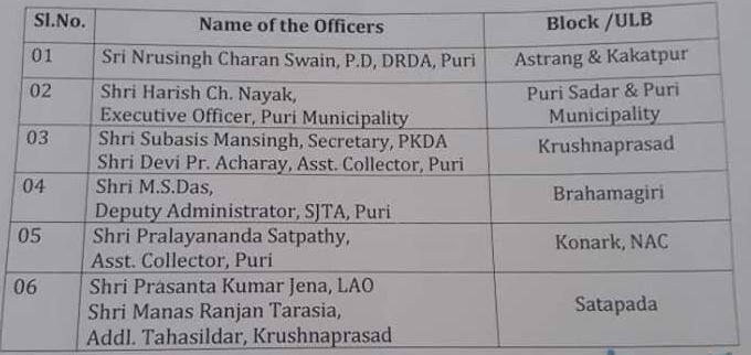
## In view of the cyclone, officers have been deployed to different areas to supervise the evacuation of people to the cyclone shelter centres, rescue and relief operation. Here is the list:

## Let us have a look at the rainfall expected during and before the landfall:
May 2: Places in South Coastal Odisha like Gajapati, Ganjam, Khordha, Rayagada, Kandhamal and Koraput would start receiving heavy to very heavy rains. Eventually, the spread of rains would increase and cover parts of North Coastal Odisha. Most of the coastal stations such as Puri, Bhubaneswar, Cuttack, Kendrapara, Balasore and Bhadrak would start receiving heavy rains. The wind speed over the Odisha coast is expected to increase to the tune of 100-120 kmph, gusting up to 140 kmph. Sea conditions are expected to be rough to very rough all along the coast of Odisha and we advise complete suspension of fishing activities.
May 3: With extremely severe cyclone Fani preparing to make landfall, rains would increase by manifolds. Coastal areas would see heavy to extremely heavy rains, wherein few places might see rains reaching up to 200 mm as well. Damaging winds would be at peak with speed of 175-185 Kmph, gusting up to 205 kmph at the time of crossing the coast. Sea tides would be high between 12 ft to 18 ft above the astronomical tide, leading to flooding. Sea conditions are expected to be rough to very rough all along the coast of Odisha and we advise complete suspension of fishing activities. Interior areas such as Angul, Kandhamal, Kendujhar, Deogarh, Phulbani, Kalahandi, Malkangiri would too receive light to moderate rain with few heavy spells.
May 4: By this time, Fani would have moved further north towards West Bengal and weakened as well. Thus, the weather over Odisha would improve. We expect only light rains at few places but strong south-westerly winds in the order of 60-70 kmph gusting to 80-90 kmph would continue along the coast.
## A red alert has been sounded in Srikakulam district of north coastal Andhra Pradesh as heavy rains with winds gusting up to 120 kmph are likely under the influence of the extremely severe cyclonic storm Fani.
## A total of six Disaster Response Teams (DRT) of the Indian Coast Guard have been deployed in Bengal-- four in Haldia and two in Frazerganj. 1 lakh people will be evacuated from the lower side of Puri on Thursday.
## A total of 47 flood rescue and relief teams have been prepositioned in 25 vulnerable/coastal areas of West Bengal, Odisha, Andhra Pradesh, Tamil Nadu and Kerala to meet any eventuality arising due to cyclone. In addition, 24 teams are on alert standby at NDRF bases: National Disaster Response Force (NDRF).
## PM Narendra Modi’s election campaign/ public rally in Jhargram and Tamluk in West Bengal on May 5, has been postponed.


No comments:
Post a Comment
Thanks keep touch with us